Netherton House,
West Netherton Street,
Kilmarnock, Ayrshire,
KA1 4BU
Case Study - Westfield ROAV Survey

This summer L&M completed our first project partly undertaken using ROAVs – Remotely Operated Aerial Vehicles, more commonly known as drones.
At one time, Westfield was one of the largest surface mines in the UK, extending to 420 hectares, with coal extraction ceasing in 1998. L&M Surveys were asked to prepare a detailed topographic survey of the whole site to assist the proposed works. The development proposals take an integrated approach to regenerating this historically impacted site. The client will improve the biodiversity of the site, increase public accessibility and incorporate a range of renewable energy systems, including energy recovery from residual waste. This energy can then support other development proposals and a range of new business opportunities.
Due to the large size of the site, a different approach was considered and it was decided that we’d utilise ROAVs for the first time. Cyberhawk were subcontracted to do the work and they completed the survey of the whole site in one day. They provided the data as a point-cloud that was then imported into the LSS 3D Vision software. From there, the usual links could be digitised in to a normal LSS file. This approach saved multiple days of traditional site survey however, the ROAV data was used only for open areas and the data was complemented by traditional survey methods. Well done to the various members of staff who struggled through some very challenging areas during the hottest summer in 40 years.

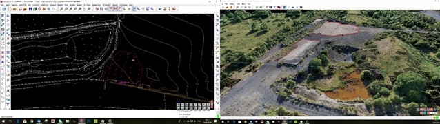
Finally, all the data was compiled to create one data set and a 3D model was issued to the client ahead of schedule and within budget. A successful first step into what will no doubt become an important future market for the company.